Last Glacial Maximum precipitation pattern in the Alps inferred from glacier modelling

Published: Dec 1, 2016 by The PISM Authors
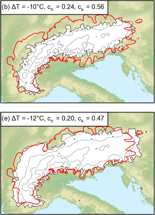
   
Title Last Glacial Maximum precipitation pattern in the Alps inferred from glacier modelling
Authors P. Becker and others
Venue Geographica Helvetica

During the Last Glacial Maximum (LGM), glaciers in the Alps reached a maximum extent well-beyond their current coverage (red line). This study models the ice cap using PISM and parameterized forms of the uncertain LGM precipitation pattern. Constraints on the model come from geomorphological reconstruction of ice extent based on interpretation of moraines, trimlines and erratic boulders. The model is forced using different temperature cooling and precipitation reduction factors. Use of the present-day precipitation pattern leads to a systematic overestimation of the ice cover on the northern part of the Alps relative to the southern part. A more severe decrease in precipitation in the north was required to reproduce the LGM extent. This result supports a southwesterly advection of atmospheric moisture to the Alps, sustained by a southward shift of the North Atlantic storm track during the LGM.

Share

Latest news

PIK Potsdam: PostDoc positions in ice sheet and Earth system modelling

A two-year PostDoc positions in ice sheet and Earth system modelling is available in the Ice Dynamics group, as part of the new Earth Resilience Science Unit (ERSU), at the Potsdam Institute for Climate Impact Research (PIK).

U Copenhagen: 2 PhD positions in ice sheet modelling at the Niels Bohr Institute

Two PhD fellowship positions in ice sheet modelling are advertised at the Niels Bohr Institute, University of Copenhagen.

AWI Bremerhaven: PhD position Projections of future sea-level rise from coupled ice sheet-ocean modelling

The Alfred Wegener Institute, Bremerhaven, is offering a PhD position in the field of coupled ice sheet-ocean modelling. The core of the project is to run simulations with FESOM-PISM (a coupled ocean-ice shelf-ice sheet model with evolving cavity geometries) for different 21st-century climate projections to obtain well-constrained trajectories of future ice mass loss from the vast Antarctic Ice Sheet. Model results will feed into a fingerprinting method that considers the ocean response as well as gravitational effects and contributions from other sources. The final product will be a time series of global maps of regional sea-level variations that consider all of the most relevant processes.